
PURPOSE OF CHAIN SURVEYING AND PRINCIPLES OF CHAIN SURVEYING
Chain surveying is a type of land surveying method that is used to measure and map the boundaries, features, and contours of a piece of land. In this method, a measuring chain or tape is used to measure the distances between points on the land surface.
The main components of a chain survey are:
- Measuring chain or tape: A chain or tape is used to measure the distances between points. The chain is made up of a number of links, usually 100 or 200 links, with each link measuring a fixed distance.
- Ranging rods: These are used to mark the end points of the chain and to keep the chain straight during measurement.
- Pegs: These are used to mark the points where measurements are taken.
- Compass: A compass is used to determine the directions and angles between points.
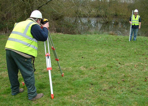
- Leveling instrument: A leveling instrument, such as a spirit level, is used to ensure that the survey is level and to measure elevations.
The steps involved in a chain survey are:
- Reconnaissance: The surveyor visits the site to familiarize themselves with the area and identify key features that need to be surveyed.
- Marking of reference points: The surveyor marks a reference point on the ground, which will serve as the starting point for the survey.
- Measuring of distances: The surveyor uses a chain or tape to measure the distances between points on the land surface. The ranging rods are used to ensure that the chain is straight and accurate.
- Determination of angles: The surveyor uses a compass to determine the angles between points.
- Levelling: The surveyor uses a leveling instrument to ensure that the survey is level and to measure elevations.
- Recording of measurements: The surveyor records all measurements in a field book or notebook.
- Plotting: The measurements recorded in the field book are then plotted on a map or plan to create an accurate representation of the land surveyed.
Chain surveying is a simple and accurate method of surveying that can be used for small areas. However, it can be time-consuming and labor-intensive for larger areas
Chain surveying is a type of land surveying that involves the use of a measuring chain to measure distances and a set of other instruments to determine angles and elevations. The main purpose of chain surveying is to measure and map the boundaries, contours, and features of a piece of land for various purposes, including planning and development, land ownership disputes, and construction projects.
The principles of chain surveying include:
- Linear measurement: The measurement of distance between two points is the fundamental principle of chain surveying. A chain or tape is used to measure the distance between points.
- Accuracy: The measurements obtained through chain surveying must be accurate and reliable. This requires the use of precise instruments and careful techniques.
- Orientation: The survey must be oriented correctly to a known benchmark or reference point. This is done to ensure that the survey is consistent with other surveys in the area and to avoid errors in the measurements.
- Leveling: The survey must be leveled accurately to ensure that the elevations are correct.
- Booking: The measurements obtained during the survey must be recorded in a systematic and organized manner in a field book.
- Plotting: The measurements recorded in the field book are then plotted on a map or plan to create an accurate representation of the land surveyed.
- Compass survey: The principles of compass surveying are also used in chain surveying to determine the angles between points and to establish the orientation of the survey.

FOR MANY MORE UPDATES AVAILABLE CLICK BELOW
CLICK THE BELOW LINK TO READ THE COMPLETE CONTENTS, SOME CONTENTS OF THIS WEBSITE ARE FOR GOLD SUBSCRIBERS ONLY. Join us as a GOLD SUBSCRIBER and get access to read important books. CEV LIBRARY GOLD SUBSCRIPTION
KIND ATTENTION
We are going to close all what’s groups of CEV soon due to difficulties in posting information or message in more than 5 groups of CEV at a time. All future posts of empanelment notices & professional importance will be shared on
1. https://t.me/+dbHNkNO22xsyYTY1
2. www.valuerworld.com
3. The Twitter handle of CEV India https://twitter.com/cevindia?t=XbqlvnwUVz1G3uPgs749ww&s=09 after closing the groups. All members of these groups are requested to register themselves at the following link immediately for Getting all related timely updates