
THE ARCHITECTURE OF AGRARIAN ADMINISTRATION
A COMPREHENSIVE ANALYSIS OF INDIAN LAND REVENUE RECORDS AND TERMINOLOGY
Author-Er. Avinash Kamble
CEV/IAF/RVO/VM/819/PM
IBBI/RV/10/2022/15103
Land revenue administration is a very complex and highly structured system. There is no single way to understand it without looking at how it has changed over time. The framework we use today in India is an ancient system that was heavily influenced by historical decrees and the administrative reorganizations of different rulers. Tracing its roots back to the agrarian reforms initiated by Sher Shah Suri and the highly sophisticated revenue system implemented during the Mughal era, the terminology of Indian land records is essentially steeped in Perso-Arabic words. During the British period, different regional settlement systems—such as the Permanent Settlement in Bengal and the Mahalwari system in North-Western India—were introduced, which further shaped this vocabulary. Words like Zamindar and Mahal became socially accepted terms that people used every day.
In contemporary society, understanding this system is very important if someone wants to deal with property rights, agricultural leasing, or real estate. For a long time, people were dependent upon fragile, physical parchment records maintained by village accountants. However, quite often, these records were difficult to manage, so they are currently undergoing a radical transformation. Through modern digitization efforts like the SVAMITVA scheme, these old records are being systematically translated into digital formats.
We will see in this article how the Indian land records are structured, looking closely at the revenue terminology, the formats of the Jamabandi, the concept of Laal Lakeer, the types of mortgages, the different transfer documents, and finally, how one can read an Aks Shijra to calculate land shares.
PART I
Revenue Terminology Commonly Used in India
To accurately decipher the land records, one must first understand the basic terminology. This vocabulary encompasses geographic divisions, ownership structures, and cultivation arrangements. Because the system evolved over centuries, the meaning of these terms sometimes varies with historical and regional context, but they generally overlap with each other in their basic purpose.
The triad of land identification rests on three main pillars: the Khewat, the Khatauni, and the Khasra.
- The Khewat is essentially the primary owner’s account. It functions as a master list detailing an owner’s entire landholding within a specific village.
- The Khatauni operates as the cultivator’s ledger. It groups all the land parcels cultivated by a specific person, even if they are just a tenant farmer. The word Khata is a more generalized term denoting the consolidated account of a family.
- The Khasra is the specific, officially demarcated plot number assigned to a piece of land. It corresponds directly to a geometric shape drawn on the village map.
The ultimate consolidation of all these records is the Jamabandi, which is widely accepted as the Record of Rights. When a person needs proof of their land, they apply for a Fard, which is just a certified copy of the Jamabandi.
When we start imagining the village geography, certain terms are very prominent. A Mauza refers to the revenue village itself, while a Hadbast number is the serial number assigned to that village’s boundary. Within the village, the society was often divided into different communities called a Patti or Taraf. Any land that was held communally by these groups, rather than by an individual, is called Shamlat.
The taxation of the land is inextricably linked to its irrigation and soil quality. Land that is completely uncultivable is called Banjar. This is further divided into Banjar Jadid (new fallow land uncultivated for four harvests) and Banjar Kadim (old fallow land uncultivated for eight harvests). Land that is permanently covered by structures is Gair Mumkin. For cultivable land, Chahi means it is irrigated by a well, Nahri means it is irrigated by a canal, and Barani means it is entirely dependent on rainfall.
The people who work the land also have specific titles. The Kashtkar is the person physically cultivating the soil. If the owner cultivates it himself, it is called Khud Kasht. If the land is leased, a permanent, protected tenant is called a Marusi, while a temporary, unauthorized tenant is a Gair Marusi. The crop-sharing agreement between them is known as Batai, and the specific fractions of the harvest shared are denoted by terms like Nisafi (one-half) or Tihai (one-third).
PART II
Format of Jamabandi: Rural and Abadi
The Jamabandi acts as the ultimate repository of truth for land ownership. Traditionally, the Jamabandi was formulated only for agricultural lands because those were the lands that yielded tax revenue for the state. However, it has evolved over time to include Abadi (city/habitation) formats as well.
The Rural Jamabandi
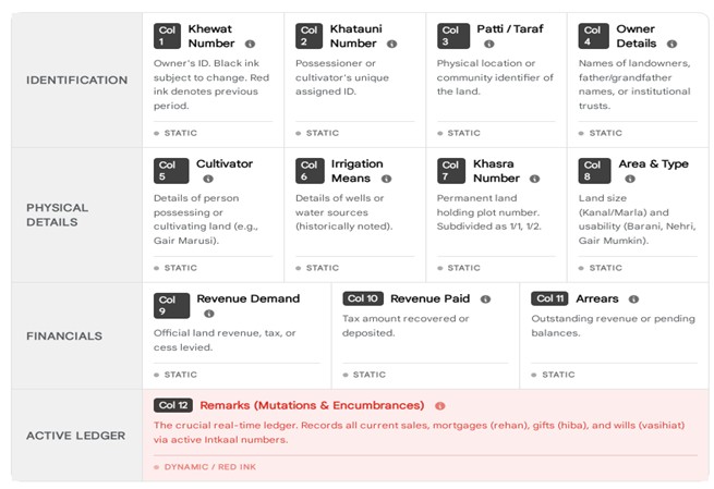
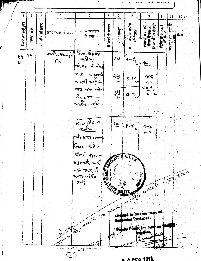
The conventional rural Jamabandi is meticulously structured into 12 standard columns. This format provides a holistic view of the ownership, cultivation, and financial status of the land. It is generally revised every five years by the village Patwari. The following 12 characteristics are found in the standard format:
- Khewat Number: This is the master holding number of the owner. It is written in black ink and changes in the next five-year cycle.
- Khatauni Number: This represents the specific account number of the person in actual physical possession or cultivation of the land.
- Patti, Taraf, or Numberdar: This specifies the exact socio-geographic location of the land within the village, usually based on community or clan.
- Detail of Owners (Malik): This contains the verified identity of the landowners, including their father’s and grandfather’s names to avoid any confusion.
- Detail of Cultivator (Kashtkar): This specifies explicitly who is physically tilling the soil, such as a Khudkast owner or a Gair Marusi
- Naam Chah (Well Details): Historically, this denoted the specific names of wells or water sources used for irrigation.
- Khasra Number: This denotes the unique plot number that corresponds to the village map.
- Area and Land Classification: This quantifies the geographic size of the land (in Kanals and Marlas) and classifies its irrigation type (like Chahi or Barani).
- Rent Detail: Specifies the exact financial rent paid by the cultivator to the owner.
- Revenue Assessment: Details the specific state land revenue assessed upon the land.
- Cesses / Duties: Records any additional local taxes payable to the state.
- Remarks (Kaifiyat): This is the most important column for current transactions. It captures all mutations (Intkal), sales, and mortgages that happen during the active 5-year cycle. These are explicitly written in red ink.
The Abadi Jamabandi
For over a century, the densely populated residential clusters inside the village (the Abadi Deh) were ignored by the revenue system because they did not generate agricultural tax. People lived there based on physical possession alone. This lack of records meant people couldn’t get bank loans for their houses. To solve this problem, the government came up with the SVAMITVA scheme. This scheme uses drones to map the village and creates an “Abadi Jamabandi” or Property Card. Unlike the 12-column rural format, this new format is highly spatial and includes a visual map, exact dimensions, owner details, and neighbor details.
PART III
Laal Lakeer Land
The concept of Laal Lakeer, or Lal Dora, is basically a red line that British colonial surveyors physically drew on village maps. The express purpose of this line was to segregate the agricultural land from the residential village site.
Any land falling inside this red line was completely exempted from agricultural land revenue. As a result, the revenue department simply stopped maintaining detailed ownership records for these properties. The legal reality for these villagers became dictated entirely by physical possession. Over generations, this became a huge problem because this unrecorded property turned into “dead capital.” Without a formal title deed, villagers were helpless and could not access the formal financial system for loans. It also led to many violent disputes over boundaries.
The leaders studied this problem and came up with a solution through Mission Lal Lakir and the SVAMITVA scheme. By using high-precision drone mapping and allowing a public verification process where villagers can raise objections, the government is now formally conferring statutory property rights to the people living inside the Laal Lakeer.
PART IV
Mortgage and its Categorizations in Jamabandi
In an agricultural society, land is often the only way a person can secure capital. Therefore, the Jamabandi is designed to record all debt encumbrances. The Persian term used for a mortgage is Rehan. When a property is mortgaged, there are two main parties: the Rahin (the mortgagor/landowner who pledges the land) and the Murtahin (the mortgagee/lender who provides the loan).
The mainstream revenue system recognizes a few different types of mortgages:
- Rahan-ba-kaza (Mortgage with Possession): Also known as Arh Rehan. In this traditional setup, the actual physical possession of the land is transferred to the lender. The lender can cultivate the land, and the harvest yield acts as the interest payment until the debt is cleared.
- Aad-Rahan (Mortgage without Possession): This is the simple mortgage used mostly by modern banks. The landowner retains full possession and continues to cultivate the land, but the property’s legal title is pledged as security. If they fail to pay, the bank can auction the land.
- Rahan-Miyadi (Periodical Mortgage): This is a conditional mortgage bound by a fixed, pre-determined time period.
When a person successfully repays their debt, the mortgage needs to be officially removed from the records. This process of cancellation or redemption is called Fak-ul-Rahin (or Fak Rehan).
It is safe to make the observation that the Remarks column (Column 12) of the Jamabandi is extremely important here. Whenever a mortgage is created, the Patwari must enter it in red ink in this column so that any future buyer can clearly see that the land is encumbered.

PART V
Different Types of Documents and Their Uses
The Jamabandi does not exist on its own. It is supported by a whole ecosystem of alternative documents and maps.
- Aks Shijra and Musavi: The Musavi is the original, foundational map of the entire village, drawn very carefully during the initial settlement. Because it is fragile and hard to update, the Patwari uses a working copy called the Aks Shijra. The Aks Shijra is used daily to record real-time changes in boundaries when land is divided or sold.
- Intkal: This is the legal process of Mutation. It is the mechanism of updating the Jamabandi to reflect a change in ownership.
- Bainama: A standard, legally registered sale deed used when land is permanently sold.
- Pata Nama: A formal lease deed document used when land is given on a long-term lease.
- Hiba Nama: A deed of gift, where property is voluntarily transferred to someone else without any money involved.
- Mukhtiarnama: This is a Power of Attorney. It gives an agent the legal authority to act on behalf of the landowner. It can be general (Aam) or highly specific to one transaction (Khaas).
PART VI
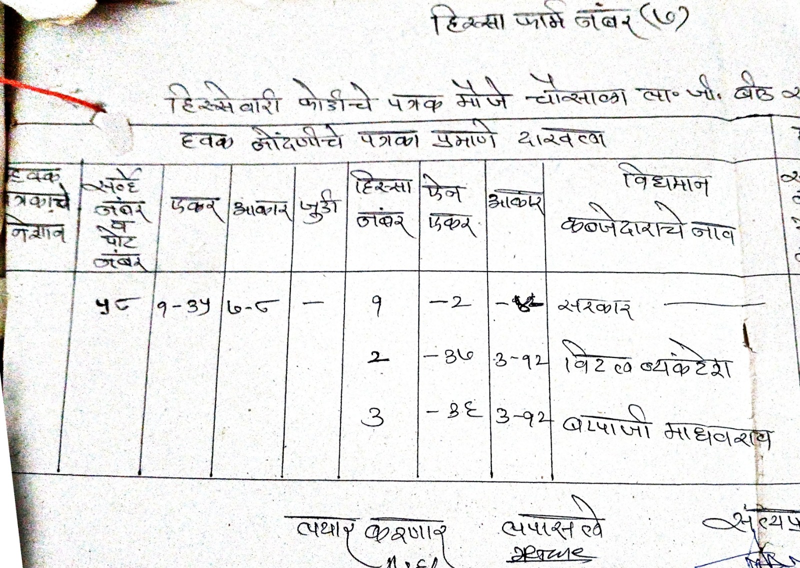
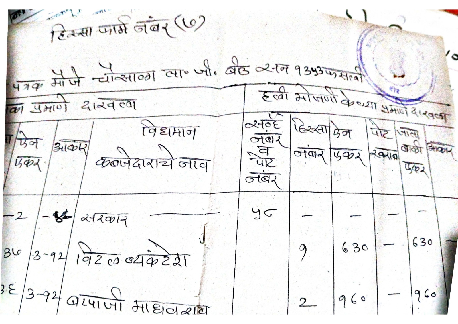
How to Read Aks Shijra and Fard Jamabandi with Calculation of Shares
For anyone looking to buy or manage land, reading the Fard Jamabandi and the Aks Shijra is very important. When reading the village map (Aks Shijra), one looks for the individual plots (Khasras) which are marked by boundary lines.
When reading the text of the Fard, two words are very prominent: Salam and Min. If a transaction mentions Salam, it means the entire, complete plot is being transferred. If it says Min, it means only a portion or a fraction of that plot is involved.
Calculation of Shares
To calculate the shares, one must first understand the units of measurement. In North-Western India, the Kanal-Marla system is quite prevalent. The basic rules are:
- 9 Sarsahis = 1 Marla
- 20 Marlas = 1 Kanal
- 8 Kanals = 1 Acre
Quite often, large tracts of land are held jointly by a family. The Jamabandi will state the total area and the specific fractional share (Hissa) of each person. For example, if the record says Bahissa Barabar, it means the share is equally divided among the owners.
To calculate an exact share, you have to follow a simple mathematical philosophy. You convert the entire land area into the smallest unit (like Marlas), divide it by the person’s share, and then convert it back into Acres, Kanals, and Marlas.
For instance, imagine a joint holding of 12 Acres, 5 Kanals, and 14 Marlas shared equally by 4 siblings (a 1/4 share each).
- First, convert everything to Marlas. (12 Acres * 160) + (5 Kanals * 20) + 14 Marlas = 1,920 + 100 + 14 = 2,034 total Marlas.
- Next, divide by their share. 2,034 Marlas / 4 = 508.5 Marlas.
- Finally, convert this back. 508 Marlas divided by 160 gives 3 Acres (with 28 Marlas left over). 28 Marlas divided by 20 gives 1 Kanal (with 8 Marlas left over).
So, the exact share of one sibling is 3 Acres, 1 Kanal, and 8 Marlas (plus the 0.5 Marla remainder, which equals 4.5 Sarsahis).
We have seen in this article how the agrarian administration operates and how these historical records, though sometimes confusing, form the backbone of Indian land rights.
???? Exclusive Interview: Understanding Indian Land Revenue Records
Interview with Er. Avinash Kamble
Q1. Your article traces the roots of Indian land revenue systems back to historical regimes like Sher Shah Suri and the Mughal era. How does this historical evolution impact present-day land administration?
Answer:
The present system is deeply rooted in historical frameworks. Many of the terminologies and structural concepts we use today were developed during those periods. While they provided a strong administrative foundation, they also introduced complexity due to linguistic and regional variations. This historical layering makes interpretation challenging for modern professionals, especially when dealing with legacy records.
Q2. You highlighted the importance of Khewat, Khatauni, and Khasra. Why are these three elements critical for land identification?
Answer:
These three form the backbone of land records. Khewat identifies ownership, Khatauni reflects cultivation, and Khasra pinpoints the exact plot on the map. Without understanding this triad, it is impossible to accurately interpret land ownership, usage, or valuation.
Q3. You describe Jamabandi as the “Record of Rights.” How reliable is it in legal and valuation contexts today?
Answer:
Jamabandi is considered a primary document of land rights, but it is not infallible. Its reliability depends on timely updates and accurate mutation entries. Professionals must always cross-verify it with supporting documents like Aks Shijra and registered deeds.
Q4. With initiatives like the SVAMITVA Scheme, how do you see digitization transforming land records in India?
Answer:
Digitization is a game changer. The SVAMITVA scheme introduces drone-based mapping and property cards, especially for abadi areas. It improves transparency, reduces disputes, and enhances accessibility to financial systems. However, implementation consistency across states remains a challenge.
Q5. The concept of Laal Lakeer has historically created issues of “dead capital.” Can modern reforms fully resolve this problem?
Answer:
Yes, to a large extent. Earlier, properties within Laal Lakeer lacked formal documentation, making them economically inactive. With modern mapping and legal recognition under schemes like SVAMITVA, these properties are now becoming bankable assets. However, awareness and dispute resolution mechanisms are still evolving.
Q6. You discussed traditional mortgage concepts such as Rehan and Aad-Rahan. Are these still relevant in today’s financial ecosystem?
Answer:
While modern banking uses standardized legal frameworks, these traditional concepts still appear in revenue records. Understanding them is essential for interpreting historical encumbrances and ensuring clear title verification during valuation or transactions.
Q7. The Remarks column (Kaifiyat) in Jamabandi seems crucial. Why is it often considered the most important column?
Answer:
Because it records real-time changes such as sales, mortgages, and mutations. These entries directly impact ownership and legal status. Ignoring this column can lead to serious errors, including overlooking encumbrances or disputed ownership.
Q8. How do documents like Aks Shijra and Musavi complement textual land records?
Answer:
They provide spatial clarity. While Jamabandi gives textual details, Aks Shijra visually represents land parcels and boundaries. Together, they ensure a complete understanding of both legal and physical aspects of land.
Q9. Your article explains land share calculations in Kanal-Marla units. How important is this practical knowledge for valuers?
Answer:
It is extremely important. Many landholdings are joint, and accurate share calculation is essential for valuation, partition, and transactions. Without this skill, even experienced professionals can misinterpret ownership proportions.
Q10. What key advice would you give to young engineers and valuers entering this field?
Answer:
They should develop a strong foundation in revenue terminology, understand both textual and spatial records, and stay updated with digitization initiatives. Combining technical knowledge with legal awareness is the key to becoming a competent valuer in India.

https://youtu.be/XRCXR4aw6Bo?si=IKuK_L6VnaJnl-43