THE ROLE OF REMOTE SENSING AND GIS IN IRRIGATION PLANNING AND MANAGEMENT
THE ROLE OF REMOTE SENSING AND GIS IN IRRIGATION PLANNING AND MANAGEMENT
Irrigation is a crucial component of modern agriculture, enabling farmers to enhance crop productivity and ensure food security. However, the efficient and sustainable management of irrigation systems is a complex task that requires accurate data, real-time monitoring, and informed decision-making. This is where Remote Sensing and Geographic Information Systems (GIS) play a pivotal role in revolutionizing irrigation planning and management. In this article, we will explore how these technologies are transforming the way we approach irrigation.
Understanding Remote Sensing
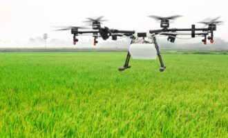
Remote sensing involves collecting information about the Earth’s surface from a distance, typically using satellites, drones, or aircraft. This technology provides valuable data for irrigation management through various sensors, including optical and thermal sensors, radar, and LiDAR. These sensors can capture a wide range of data, such as land cover, soil moisture, temperature, and vegetation health.
Key Points:
- Remote sensing collects data about the Earth’s surface from a distance.
- Various sensors capture data on land cover, soil moisture, temperature, and vegetation health.
The Role of Remote Sensing in Irrigation Planning and Management
- Crop Monitoring: Remote sensing enables the monitoring of crop health and growth throughout the growing season. This information helps farmers optimize irrigation schedules, ensuring that water is applied when and where it is needed most.
- Soil Moisture Assessment: By measuring soil moisture content, remote sensing allows for precise irrigation. Farmers can avoid over-irrigation, which not only conserves water but also prevents waterlogging and salinization of the soil.
- Drought Detection: Remote sensing helps identify drought-prone areas, enabling early intervention and resource allocation to support affected regions.
- Land Use Planning: Satellite imagery and other remote sensing data aid in land use planning, facilitating the selection of suitable locations for irrigation infrastructure.
- Water Resource Management: Remote sensing helps assess the availability of water resources, contributing to sustainable water management practices.
Key Points:
- Crop monitoring aids in optimizing irrigation schedules.
- Soil moisture assessment prevents over-irrigation and soil issues.
- Drought detection supports early intervention.
- Land use planning and water resource management benefit from remote sensing data.
Understanding Geographic Information Systems (GIS)
GIS is a technology that integrates spatial data (geographic information) with attribute data. It allows for data analysis, visualization, and decision-making by creating maps and models. In the context of irrigation, GIS is essential for organizing and analyzing spatial information related to irrigation systems, land use, and other relevant factors.
Key Points:
- GIS integrates spatial data with attribute data.
- It facilitates data analysis, visualization, and decision-making through maps and models.
The Role of GIS in Irrigation Planning and Management
- Data Integration: GIS enables the integration of various data layers, such as soil types, land use, topography, and water sources. This integration provides a holistic view of the irrigation system, helping planners make informed decisions.
- Irrigation Network Design: GIS aids in designing efficient irrigation networks by identifying suitable locations for canals, pipelines, and reservoirs. It considers factors like slope, soil quality, and crop types.
- Risk Assessment: GIS is instrumental in assessing and mitigating the risks associated with irrigation, such as flooding and soil erosion. It helps identify vulnerable areas and plan protective measures.
- Real-Time Monitoring: GIS can be used for real-time monitoring of irrigation systems, allowing for immediate responses to any issues or inefficiencies.
- Resource Allocation: GIS supports the allocation of resources, such as labor and equipment, by optimizing routes and schedules based on spatial data.
Key Points:
- GIS integrates data layers for holistic decision-making.
- It assists in irrigation network design and risk assessment.
- Real-time monitoring and resource allocation benefit from GIS technology.
Conclusion
Remote sensing and GIS have become indispensable tools in irrigation planning and management. They offer a range of benefits, from optimizing irrigation schedules and preventing over-irrigation to supporting real-time monitoring and resource allocation. As technology continues to advance, the role of remote sensing and GIS in agriculture, particularly in irrigation, will only become more significant. These tools are key to enhancing agricultural productivity while conserving resources and promoting sustainability in the face of changing climate conditions. Farmers and policymakers should embrace these technologies to ensure food security and economic prosperity in an increasingly complex agricultural landscape.