SURVEYING IN DISASTER MANAGEMENT: MAPPING FOR EMERGENCY RESPONSE
Surveying in Disaster Management: Mapping for Emergency Response
Disasters, whether natural or man-made, strike unexpectedly and can cause significant damage to communities, infrastructure, and the environment. Effective disaster management and response are crucial for minimizing loss of life and property. One vital tool in this endeavor is surveying and mapping, which plays a pivotal role in enabling emergency response teams to make informed decisions and efficiently allocate resources during a crisis. In this article, we will explore the significance of surveying in disaster management and its role in creating essential maps for emergency response.
Understanding the Importance of Surveying in Disaster Management
- Early Warning Systems: Surveying technologies such as remote sensing and geographic information systems (GIS) help monitor environmental parameters, providing early warning about potential disasters. This data enables authorities to take preventive measures and issue timely alerts.
- Risk Assessment: Surveying and mapping assist in identifying vulnerable areas and assessing the level of risk posed by different types of disasters, including floods, earthquakes, hurricanes, and more. This information is essential for planning and preparedness.
- Resource Allocation: During an emergency, the efficient allocation of resources like personnel, equipment, and supplies is critical. Surveying helps create detailed maps that allow first responders to identify priority areas, such as damaged infrastructure or areas with trapped survivors.
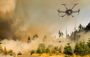
- Search and Rescue: High-resolution aerial imagery and GIS data help search and rescue teams navigate disaster-stricken areas, locate survivors, and plan rescue operations.
Technologies and Methods in Disaster Surveying
- Remote Sensing: Satellite imagery and aerial photography provide a bird’s-eye view of disaster-affected areas. These images are invaluable for assessing damage and planning emergency response strategies.

- Lidar Technology: Light Detection and Ranging (Lidar) uses laser beams to create detailed 3D maps of terrain. Lidar can identify changes in topography, which is essential for assessing the impact of landslides, tsunamis, and earthquakes.
- GIS (Geographic Information Systems): GIS technology helps manage, analyze, and visualize spatial data. During a disaster, GIS tools enable the creation of interactive maps that include critical information such as road closures, evacuation routes, and shelters.
- Drones: Unmanned aerial vehicles (UAVs) or drones are versatile tools for rapid assessment. They can capture high-resolution images, perform aerial surveys, and reach inaccessible or dangerous areas.
Challenges in Disaster Surveying and Mapping
- Data Integration: Different agencies often use disparate data sources and formats, making integration challenging. A unified data-sharing protocol can significantly improve coordination.
- Real-Time Updates: Disasters are dynamic, with evolving situations. Maintaining real-time data for emergency responders can be complex but is crucial for effective decision-making.

- Access to Technology: Some regions, especially in developing countries, may lack access to advanced surveying and mapping technologies, hindering their disaster management efforts.
- Data Security: Protecting sensitive data and ensuring its availability during a disaster is a concern. Data backup and security measures are essential.
Surveying and mapping are integral components of disaster management and emergency response. By leveraging advanced technologies and methodologies, authorities can enhance their preparedness and response strategies. Early warning, risk assessment, resource allocation, search and rescue operations, and more can all benefit from the data and maps generated through surveying efforts. Ensuring that surveying tools and information are readily available and that data integration and real-time updates are addressed will be crucial in optimizing disaster response efforts and ultimately saving lives and reducing the impact of disasters.