AERIAL SURVEYING: DRONES AND LiDAR FOR HIGH-RESOLUTION MAPPING
Aerial surveying has undergone a transformative revolution in recent years, thanks to the integration of drones (Unmanned Aerial Vehicles or UAVs) and LiDAR (Light Detection and Ranging) technology. This dynamic combination has revolutionized the way we capture and analyze geographic data, enabling high-resolution mapping and a wide range of applications across various industries. In this article, we will delve into the world of aerial surveying with drones and LiDAR, exploring its key benefits and applications.
1. Precision Mapping with Drones
Drones have become indispensable tools for aerial surveying due to their agility, affordability, and ease of use. Key advantages include:
a. Versatility
Drones can access hard-to-reach or dangerous areas, making them ideal for mapping in rugged terrains, disaster-stricken zones, or densely vegetated regions where traditional surveying methods would be impractical.
b. Cost-efficiency
Compared to traditional aerial surveying methods, drones reduce costs significantly. They require fewer resources, such as aircraft and personnel, making mapping projects more budget-friendly.
c. Real-time Data Acquisition
Drones provide real-time data, allowing surveyors to adapt their flight plans on the spot and make informed decisions during the surveying process.
d. High-resolution Imagery
Modern drones are equipped with high-quality cameras that capture sharp and detailed imagery. This is crucial for creating accurate maps and 3D models.
2. LiDAR: The Technology Behind Precision
LiDAR technology complements drones in aerial surveying by emitting laser pulses and measuring the time it takes for them to return. Key benefits include:
a. Penetrating Obstacles
LiDAR can penetrate vegetation and detect terrain beneath, enabling accurate mapping in areas where traditional photogrammetry might be obstructed.
b. Elevation Data
LiDAR captures elevation data with exceptional accuracy, allowing for the creation of detailed digital elevation models (DEMs) and digital surface models (DSMs).
c. 3D Mapping
LiDAR enables the creation of high-resolution 3D maps and models, providing valuable insights for various applications.
d. Speed and Efficiency
LiDAR technology can cover large areas quickly, making it an efficient tool for mapping extensive regions.
3. Applications of Aerial Surveying
The combination of drones and LiDAR has opened up a multitude of applications across various industries:
a. Environmental Monitoring
Aerial surveying is invaluable for monitoring changes in natural landscapes, tracking deforestation, assessing wetland health, and identifying ecological trends.
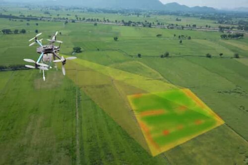
b. Agriculture
Precision agriculture relies on high-resolution mapping to optimize crop management, monitor soil conditions, and detect crop stress early on.
c. Construction and Infrastructure
Aerial surveying is used for site planning, progress monitoring, and quality control in construction projects, reducing costs and improving efficiency.
d. Disaster Management
Drones equipped with LiDAR can rapidly assess disaster-stricken areas, aiding in search and rescue efforts, damage assessment, and disaster preparedness.
e. Archaeology and Cultural Heritage
Archaeologists use aerial surveying to discover ancient sites and map cultural heritage, preserving historical treasures.
4. Data Processing and Analysis
The vast amount of data collected through aerial surveying requires sophisticated processing and analysis. Advanced software tools are used to generate accurate maps, 3D models, and actionable insights from raw data.
5. Regulatory and Ethical Considerations
As aerial surveying technology advances, it is essential to address regulatory and ethical concerns, including privacy issues and airspace regulations. Clear guidelines and ethical practices are crucial for responsible aerial surveying.
The integration of drones and LiDAR technology has revolutionized aerial surveying, making it more accessible, cost-effective, and precise than ever before. This powerful combination has unlocked a world of possibilities across industries, from environmental monitoring to disaster management and beyond. As technology continues to evolve, the potential applications of aerial surveying are bound to expand, further emphasizing the importance of responsible and ethical use.