PRINCIPLES OF LEVELLING
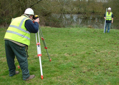
Levelling is a process used to determine the height or elevation of points on the Earth’s surface. It involves measuring the vertical distance between a point of interest and a reference point, usually a benchmark or a known elevation. Levelling is commonly used in civil engineering, construction, and surveying to create precise and accurate maps and drawings, as well as to determine the slope and gradient of the ground surface. The process typically involves the use of a levelling instrument, such as a spirit level, a digital level, or an automatic level, along with a staff or a rod held vertically at the points of interest. Levelling can be done over short distances, such as for building or landscaping projects, or over long distances, such as for creating topographic maps or for surveying large construction sites.
Levelling is the process of determining the elevation or height of a point on the earth’s surface relative to a reference datum. The principles of levelling include the following:
1. The benchmark: A benchmark is a fixed point with a known elevation used as a reference point for levelling. It is essential to have a reliable benchmark for accurate levelling.
2. The level instrument: A level instrument is used to measure the difference in height between two points. The most common type of level instrument is a spirit level, which uses a bubble to indicate when the level is horizontal.
3. The backsight and foresight: In levelling, a backsight is the first reading taken on a point of known elevation, and a foresight is the reading taken on the point being levelled. The difference between the two readings gives the height difference between the two points.
4. The booking: The process of recording the readings taken during the levelling process is called booking. The booking must be accurate and include all necessary details such as the point name, the elevation, and the distance.
5. The adjustment: Levelling is subject to errors caused by instrument, atmospheric, and human factors. Therefore, it is necessary to apply corrections to the observed readings to obtain accurate results.
6. The check: A check is necessary to ensure the accuracy of the levelling results. A check involves re-levelling the same points to ensure that the results obtained are consistent.
7. The closure: The closure is the process of checking the accuracy of the levelling by comparing the final elevation of the starting point with its initial elevation. If the difference is within an acceptable range, the levelling is said to be closed.